Universal Windows Platform (UWP)
A Microsoft platform for building and publishing apps for Windows desktop devices.
2,853 questions
This browser is no longer supported.
Upgrade to Microsoft Edge to take advantage of the latest features, security updates, and technical support.
' cx='32' cy='32' r='32' /%3E%3Ctext x='50%25' y='55%25' dominant-baseline='middle' text-anchor='middle' fill='%23FFF' %3EDB%3C/text%3E%3C/svg%3E)
I work with UWP MapControl and adding some MapPolylines. And they looks ugly (see pic below)
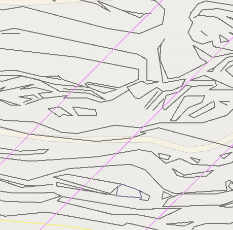
I assume should be kind of antialiasing property but cannot find it here https://learn.microsoft.com/en-us/uwp/api/windows.ui.xaml.controls.maps.mapcontrol?view=winrt-20348.
Please help and thank you!
C#
var mapPolyline = new MapPolyline();
var geoPositions = new List<BasicGeoposition>();
foreach (var vertex in polyLine.Vertex)
{
  // add BasicGeopositions...
};
mapPolyline.StrokeColor = Colors.Black;
mapPolyline.StrokeThickness = 1;
mapPolyline.Path = new Geopath(geoPositions);
((MapElementsLayer)impotMapLayer).MapElements.Add(mapPolyline);

Hi @Dmitry Boyko ,
We have the following answer for you from a member of the Microsoft Maps team:
Currently MapPolylines are drawn without antialiasing and there is no setting to change that behavior. Looking at your screenshot, you may be better served by using a custom tile layer. See CustoMapTileDatasource here: https://learn.microsoft.com/en-us/windows/uwp/maps-and-location/overlay-tiled-images You can draw each tile in a callback using whatever method you like including antialiasing. It will also tend to perform better for a large collection of static lines like the topographic contours in your example.
Sincerely,
IoTGirl
Thank you! I investigated MapTileBitmapRequestedEventArgs Class and sample code. It gives strange X, Y like X 6072 Y 6072. MSDN says: X Gets the X value of the requested tile. Y Gets the Y value of the requested tile.
Would you mind clarify what those numbers are exactly and how I can associate it with geolocations set of vertices in memory if I want create tile-image only, please? (My polylines set already calculated in geopoints.)
Thank you very much!