Load Single Boundary GeoData Example
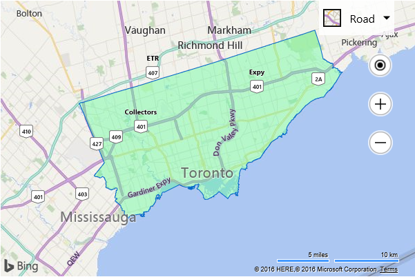
This examples renders a PopulatedPlace (city, town) boundary for the Location that is in the center of the map view when the map is loaded. The center of the map is set to (43.7, -79.3834) which is a location in Toronto, Ontario, Canada.
<!DOCTYPE html>
<html>
<head>
    <title></title>
    <meta charset="utf-8" />
	<script type='text/javascript'>
    function GetMap() {
        var map = new Microsoft.Maps.Map('#myMap', {
            credentials: ‘Your Bing Maps Key’,
            center: new Microsoft.Maps.Location(43.7, -79.3834),
            zoom: 10
        });

        //Create the request options.
        var geoDataRequestOptions = {
            entityType: 'PopulatedPlace'
        };

        //Load the Bing Spatial Data Services module.
        Microsoft.Maps.loadModule('Microsoft.Maps.SpatialDataService', function () {

            //Use the GeoData API manager to get the boundaries of the zip codes.
            Microsoft.Maps.SpatialDataService.GeoDataAPIManager.getBoundary(
                map.getCenter(),
                geoDataRequestOptions,
                map,
                function (data) {
                    //Add the polygons to the map.
                    if (data.results && data.results.length > 0) {
                        map.entities.push(data.results[0].Polygons);
                    }
                });
        });
    }
    </script>
    <script type='text/javascript' src='http://www.bing.com/api/maps/mapcontrol?callback=GetMap' async defer></script>
</head>
<body>
    <div id="myMap" style="position:relative;width:600px;height:400px;"></div>
</body>
</html>
Running this code will display a map with the boundaries of Toronto displayed.