확대/축소 수준 및 타일 그리드
Azure Maps에서는 구면 메르카토르 도법 구면좌표계를 사용합니다(EPSG:3857). 도법은 구면 지구본을 평면 지도로 변환하는 데 사용되는 수학적 모델입니다. 구면 메르카토르 도법은 극지방에서 지도를 늘여서 정사각형 지도를 만듭니다. 이 도법은 지도의 배율과 영역을 크게 왜곡하지만 이 왜곡보다 중요한 다음 두 가지 속성이 있습니다.
- 상대적으로 작은 개체의 모양을 보존하는 정각 도법입니다. 작은 개체의 모양을 보존하는 것은 항공 이미지를 표시할 때 특히 중요합니다. 건물 모양의 왜곡을 방지하려고 할 때를 예를 들어봅시다. 정사각형 건물은 직사각형이 아닌 정사각형으로 표시되어야 합니다.
- 다른 하나는 원통 도법입니다. 북쪽과 남쪽은 항상 위쪽과 아래쪽이며 서쪽과 동쪽은 항상 왼쪽과 오른쪽입니다.
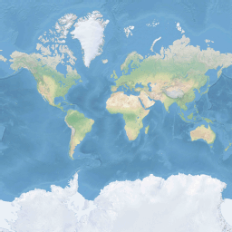
지도 검색과 표시의 성능을 최적화하기 위해 지도는 정사각형 타일로 나뉩니다. Azure Maps SDK는 도로 지도에 512x512픽셀 크기의 타일을 사용하고 위성 이미지에는 더 작은 256x256픽셀 타일을 사용합니다. Azure Maps는 0~22의 번호가 지정된 23개 확대/축소 수준의 래스터 및 벡터 타일을 제공합니다. 확대/축소 수준 0에서 전 세계는 단일 타일로 맞춰집니다.
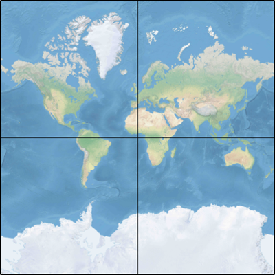
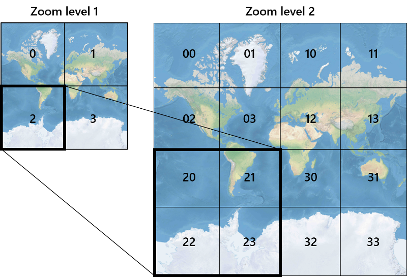
확대/축소 수준 1은 4개의 타일을 사용하여 전 세계를 2x2 사각형으로 렌더링합니다.
추가 확대/축소 수준 4개 타일은 각각 이전 수준의 타일을 4개로 나누어서 2확대/축소x2확대/축소 그리드를 만듭니다. 확대/축소 수준 22는 222 x 222 그리드 또는 4,194,304 x 4,194,304 타일(총 17,592,186,044,416개)입니다.
웹 및 Android용 Azure Maps 대화형 지도 컨트롤은 25개의 확대/축소 수준(0-24)을 지원합니다. 그러나 도로 데이터는 타일을 사용할 수 있는 경우의 확대/축소 수준에서만 사용할 수 있습니다.
다음 표에서는 타일 크기가 256픽셀 정사각형인 확대/축소 수준의 전체 값 목록을 제공합니다.
| 확대/축소 수준 | 미터/픽셀 | 미터/타일 측 |
|---|---|---|
| 0 | 156543 | 40075017 |
| 1 | 78271.5 | 20037508 |
| 2 | 39135.8 | 10018754 |
| 3 | 19567.88 | 5009377.1 |
| 4 | 9783.94 | 2504688.5 |
| 5 | 4891.97 | 1252344.3 |
| 6 | 2445.98 | 626172.1 |
| 7 | 1222.99 | 313086.1 |
| 8 | 611.5 | 156543 |
| 9 | 305.75 | 78271.5 |
| 10 | 152.87 | 39135.8 |
| 11 | 76.44 | 19567.9 |
| 12 | 38.219 | 9783.94 |
| 13 | 19.109 | 4891.97 |
| 14 | 9.555 | 2445.98 |
| 15 | 4.777 | 1222.99 |
| 16 | 2.3887 | 611.496 |
| 17 | 1.1943 | 305.748 |
| 18 | 0.5972 | 152.874 |
| 19 | 0.2986 | 76.437 |
| 20 | 0.14929 | 38.2185 |
| 21 | 0.074646 | 19.10926 |
| 22 | 0.037323 | 9.55463 |
| 23 | 0.0186615 | 4.777315 |
| 24 | 0.00933075 | 2.3886575 |
픽셀 좌표
각 확대/축소 수준에서 사용할 도법과 배율을 선택한 경우 지리적 좌표를 픽셀 좌표로 변환할 수 있습니다. 특정 확대/축소 수준에서 세계 지도 이미지의 전체 픽셀 너비와 높이는 다음과 같이 계산됩니다.
var mapWidth = tileSize * Math.pow(2, zoom);

var mapHeight = mapWidth;
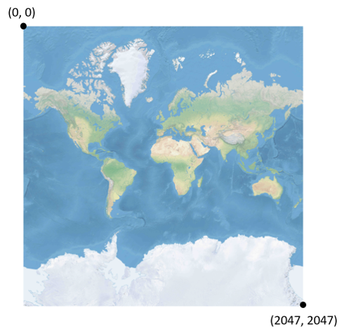
지도 너비와 높이가 각 확대/축소 수준에서 서로 다르므로 픽셀 좌표도 다릅니다. 지도의 왼쪽 위 모퉁이에 있는 픽셀에는 항상 픽셀 좌표(0, 0)가 있습니다. 지도의 오른쪽 아래 모퉁이에 있는 픽셀에는 픽셀 좌표(width-1, height-1)가 있거나 이전 섹션의 수식 (tileSize * 2zoom–1, tileSize * 2zoom–1)에 대한 참조가 있습니다. 예를 들어, 수준 2에서 512개 정사각형 타일을 사용하는 경우 픽셀 좌표 범위는 다음과 같이 (0, 0)에서 (2047, 2047)까지입니다.
위도와 경도(도) 및 세부 정보 수준의 경우 픽셀 XY 좌표는 다음과 같이 계산됩니다.
var sinLatitude = Math.sin(latitude * Math.PI/180);

var pixelX = ((longitude + 180) / 360) * tileSize * Math.pow(2, zoom);

var pixelY = (0.5 – Math.log((1 + sinLatitude) / (1 – sinLatitude)) / (4 * Math.PI)) * tileSize * Math.pow(2, zoom);
위도 및 경도 값은 WGS 84 기준면에 있는 것으로 간주합니다. Azure Maps는 구면 도법을 사용하지만 모든 지리적 좌표를 일반 데이터로 변환하는 것이 중요합니다. WGS 84는 선택된 기준면입니다. 경도 값은 -180도에서 +180도까지 범위로 간주하며 위도 값은 -85.05112878에서 85.05112878까지 범위로 고정되어야 합니다. 해당 값을 준수하면 극지방에서 특이성이 방지되며 투영된 지도가 정사각형 모양이 됩니다.
타일 좌표
지도 검색과 표시의 성능을 최적화하기 위해 렌더링된 지도는 타일로 잘립니다. 픽셀 수와 타일 수는 각 확대/축소 수준에서 달라집니다.
var numberOfTilesWide = Math.pow(2, zoom);

var numberOfTilesHigh = numberOfTilesWide;
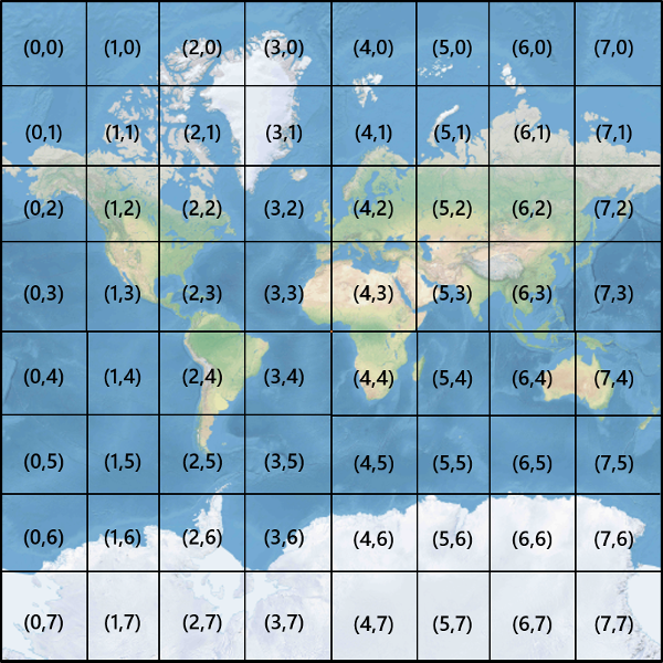
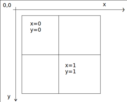
각 타일에는 왼쪽 위 (0, 0)부터 오른쪽 아래 (2zoom–1, 2zoom–1)까지 범위의 XY 좌표가 제공됩니다. 예를 들어, 확대/축소 수준 3에서 타일 좌표 범위는 다음과 같이 (0, 0)에서 (7, 7)까지입니다.
픽셀 XY 좌표 쌍의 경우 해당 픽셀을 포함하는 타일의 타일 XY 좌표를 쉽게 확인할 수 있습니다.
var tileX = Math.floor(pixelX / tileSize);

var tileY = Math.floor(pixelY / tileSize);
타일은 확대/축소 수준으로 호출됩니다. X 및 Y 좌표는 해당 확대/축소 수준의 그리드에서 타일의 위치에 해당합니다.
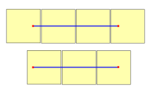
사용할 확대/축소 수준을 결정할 때 각 위치는 해당 타일의 고정된 위치에 있습니다. 따라서 지정된 범위의 지역을 표시하는 데 필요한 타일의 수는 세계 지도에서 확대/축소 그리드의 배치에 따라 달라집니다. 예를 들어 900미터 떨어진 두 개의 지점이 있는 경우 확대/축소 수준 17에서 서로 간에 경로를 표시하기 위해 세 개의 타일만을 사용할 수 있습니다. 그러나 서쪽 지점이 해당 타일의 오른쪽에 있고 동쪽 지점이 해당 타일의 왼쪽에 있는 경우 4개의 타일이 필요할 수 있습니다.
확대/축소 수준이 결정되면 x 및 y 값을 계산할 수 있습니다. 각 확대/축소 그리드의 왼쪽 위 타일은 x=0, y=0이고, 오른쪽 아래 타일은 x=2zoom-1, y=2zoom-1입니다.
확대/축소 수준 1에서 확대/축소 그리드는 다음과 같습니다.
쿼드키 인덱스
일부 매핑 플랫폼에서는 타일 ZY 좌표를 quadtree 키 또는 짧게 quadkeys라고 하는 1차원 문자열에 결합하는 quadkey 인덱싱 명명 규칙을 사용합니다. 각 quadkey는 특정 세부 정보 수준에서 단일 타일을 고유하게 식별하며 일반 데이터베이스 B-트리 인덱스에서 키로 사용할 수 있습니다. Azure Maps SDK는 타일 계층 추가 문서에 설명된 다른 명명 규칙 외에 quadkey 명명 규칙을 사용하는 타일 계층의 오버레이를 지원합니다.
참고 항목
quadkeys 명명 규칙은 1 이상의 확대/축소 수준에서만 작동합니다. Azure Maps SDK는 전 세계의 단일 지도 타일인 확대/축소 수준 0을 지원합니다.
타일 좌표를 quadkey로 변환하기 위해 Y 및 X 좌표의 비트가 인터리브되며 결과는 base-4 번호로 해석되고(앞에 오는 0이 유지됨) 문자열로 변환됩니다. 예를 들어, 수준 3에서 (3, 5)의 타일 XY 좌표의 경우 quadkey는 다음과 같이 결정됩니다.
tileX = 3 = 011 (base 2)

tileY = 5 = 101 (base 2)

quadkey = 100111 (base 2) = 213 (base 4) = "213"
Qquadkeys에는 여러 가지 흥미로운 속성이 있습니다. 첫째, quadkey의 길이(자릿수)는 해당 타일의 확대/축소 수준과 같습니다. 둘째, 임의 타일의 quadkey는 부모 타일(이전 수준에서 포함하는 타일)의 quadkey로 시작합니다. 다음 예제와 같이 타일 2는 타일 20~23의 부모입니다.
마지막으로, quadkeys는 일반적으로 XY 공간에서 타일의 근접성을 유지하는 1차원 인덱스 키를 제공합니다. 즉, 인접한 XY 좌표를 포함하는 두 타일에는 일반적으로 함께 비교적 가까운 quadkeys가 있습니다. 이는 인접한 타일이 종종 그룹으로 요청되기 때문에 데이터베이스 성능을 최적화하는 데 중요하며, 디스크 읽기 수를 최소화하기 위해 해당 타일을 동일한 디스크 블록에서 유지하는 것이 좋습니다.
타일 수학 소스 코드
다음 샘플 코드에서는 이 문서에 설명된 함수를 구현하는 방법을 보여 줍니다. 이 함수는 필요에 따라 다른 프로그래밍 언어로 쉽게 변환할 수 있습니다.
using System;
using System.Text;

namespace AzureMaps
{
    /// <summary>
    /// Tile System math for the Spherical Mercator projection coordinate system (EPSG:3857)
    /// </summary>
    public static class TileMath
    {
        //Earth radius in meters.
        private const double EarthRadius = 6378137;

        private const double MinLatitude = -85.05112878;
        private const double MaxLatitude = 85.05112878;
        private const double MinLongitude = -180;
        private const double MaxLongitude = 180;

        /// <summary>
        /// Clips a number to the specified minimum and maximum values.
        /// </summary>
        /// <param name="n">The number to clip.</param>
        /// <param name="minValue">Minimum allowable value.</param>
        /// <param name="maxValue">Maximum allowable value.</param>
        /// <returns>The clipped value.</returns>
        private static double Clip(double n, double minValue, double maxValue)
        {
            return Math.Min(Math.Max(n, minValue), maxValue);
        }

        /// <summary>
        /// Calculates width and height of the map in pixels at a specific zoom level from -180 degrees to 180 degrees.
        /// </summary>
        /// <param name="zoom">Zoom Level to calculate width at</param>
        /// <param name="tileSize">The size of the tiles in the tile pyramid.</param>
        /// <returns>Width and height of the map in pixels</returns>
        public static double MapSize(double zoom, int tileSize)
        {
            return Math.Ceiling(tileSize * Math.Pow(2, zoom));
        }

        /// <summary>
        /// Calculates the Ground resolution at a specific degree of latitude in meters per pixel.
        /// </summary>
        /// <param name="latitude">Degree of latitude to calculate resolution at</param>
        /// <param name="zoom">Zoom level to calculate resolution at</param>
        /// <param name="tileSize">The size of the tiles in the tile pyramid.</param>
        /// <returns>Ground resolution in meters per pixels</returns>
        public static double GroundResolution(double latitude, double zoom, int tileSize)
        {
            latitude = Clip(latitude, MinLatitude, MaxLatitude);
            return Math.Cos(latitude * Math.PI / 180) * 2 * Math.PI * EarthRadius / MapSize(zoom, tileSize);
        }

        /// <summary>
        /// Determines the map scale at a specified latitude, level of detail, and screen resolution.
        /// </summary>
        /// <param name="latitude">Latitude (in degrees) at which to measure the map scale.</param>
        /// <param name="zoom">Level of detail, from 1 (lowest detail) to 23 (highest detail).</param>
        /// <param name="screenDpi">Resolution of the screen, in dots per inch.</param>
        /// <param name="tileSize">The size of the tiles in the tile pyramid.</param>
        /// <returns>The map scale, expressed as the denominator N of the ratio 1 : N.</returns>
        public static double MapScale(double latitude, double zoom, int screenDpi, int tileSize)
        {
            return GroundResolution(latitude, zoom, tileSize) * screenDpi / 0.0254;
        }

        /// <summary>
        /// Global Converts a Pixel coordinate into a geospatial coordinate at a specified zoom level.
        /// Global Pixel coordinates are relative to the top left corner of the map (90, -180)
        /// </summary>
        /// <param name="pixel">Pixel coordinates in the format of [x, y].</param>
        /// <param name="zoom">Zoom level</param>
        /// <param name="tileSize">The size of the tiles in the tile pyramid.</param>
        /// <returns>A position value in the format [longitude, latitude].</returns>
        public static double[] GlobalPixelToPosition(double[] pixel, double zoom, int tileSize)
        {
            var mapSize = MapSize(zoom, tileSize);

            var x = (Clip(pixel[0], 0, mapSize - 1) / mapSize) - 0.5;
            var y = 0.5 - (Clip(pixel[1], 0, mapSize - 1) / mapSize);

            return new double[] {
                360 * x,    //Longitude
                90 - 360 * Math.Atan(Math.Exp(-y * 2 * Math.PI)) / Math.PI  //Latitude
            };
        }

        /// <summary>
        /// Converts a point from latitude/longitude WGS-84 coordinates (in degrees) into pixel XY coordinates at a specified level of detail.
        /// </summary>
        /// <param name="position">Position coordinate in the format [longitude, latitude]</param>
        /// <param name="zoom">Zoom level.</param>
        /// <param name="tileSize">The size of the tiles in the tile pyramid.</param>
        /// <returns>A global pixel coordinate.</returns>
        public static double[] PositionToGlobalPixel(double[] position, int zoom, int tileSize)
        {
            var latitude = Clip(position[1], MinLatitude, MaxLatitude);
            var longitude = Clip(position[0], MinLongitude, MaxLongitude);

            var x = (longitude + 180) / 360;
            var sinLatitude = Math.Sin(latitude * Math.PI / 180);
            var y = 0.5 - Math.Log((1 + sinLatitude) / (1 - sinLatitude)) / (4 * Math.PI);

            var mapSize = MapSize(zoom, tileSize);

            return new double[] {
                 Clip(x * mapSize + 0.5, 0, mapSize - 1),
                 Clip(y * mapSize + 0.5, 0, mapSize - 1)
            };
        }

        /// <summary>
        /// Converts pixel XY coordinates into tile XY coordinates of the tile containing the specified pixel.
        /// </summary>
        /// <param name="pixel">Pixel coordinates in the format of [x, y].</param>
        /// <param name="tileSize">The size of the tiles in the tile pyramid.</param>
        /// <param name="tileX">Output parameter receiving the tile X coordinate.</param>
        /// <param name="tileY">Output parameter receiving the tile Y coordinate.</param>
        public static void GlobalPixelToTileXY(double[] pixel, int tileSize, out int tileX, out int tileY)
        {
            tileX = (int)(pixel[0] / tileSize);
            tileY = (int)(pixel[1] / tileSize);
        }

        /// <summary>
        /// Performs a scale transform on a global pixel value from one zoom level to another.
        /// </summary>
        /// <param name="pixel">Pixel coordinates in the format of [x, y].</param>
        /// <param name="oldZoom">The zoom level in which the input global pixel value is from.</param>
        /// <returns>A scale pixel coordinate.</returns>
        public static double[] ScaleGlobalPixel(double[] pixel, double oldZoom, double newZoom)
        {
            var scale = Math.Pow(2, oldZoom - newZoom);

            return new double[] { pixel[0] * scale, pixel[1] * scale };
        }

        /// <summary>
        /// Performs a scale transform on a set of global pixel values from one zoom level to another.
        /// </summary>
        /// <param name="pixels">A set of global pixel value from the old zoom level. Points are in the format [x,y].</param>
        /// <param name="oldZoom">The zoom level in which the input global pixel values is from.</param>
        /// <param name="newZoom">The new zoom level in which the output global pixel values should be aligned with.</param>
        /// <returns>A set of global pixel values that has been scaled for the new zoom level.</returns>
        public static double[][] ScaleGlobalPixels(double[][] pixels, double oldZoom, double newZoom)
        {
            var scale = Math.Pow(2, oldZoom - newZoom);

            var output = new System.Collections.Generic.List<double[]>();
            foreach (var p in pixels)
            {
                output.Add(new double[] { p[0] * scale, p[1] * scale });
            }

            return output.ToArray();
        }

        /// <summary>
        /// Converts tile XY coordinates into a global pixel XY coordinates of the upper-left pixel of the specified tile.
        /// </summary>
        /// <param name="tileX">Tile X coordinate.</param>
        /// <param name="tileY">Tile Y coordinate.</param>
        /// <param name="tileSize">The size of the tiles in the tile pyramid.</param>
        /// <param name="pixelX">Output parameter receiving the X coordinate of the point, in pixels.</param>
        /// <param name="pixelY">Output parameter receiving the Y coordinate of the point, in pixels.</param>
        public static double[] TileXYToGlobalPixel(int tileX, int tileY, int tileSize)
        {
            return new double[] { tileX * tileSize, tileY * tileSize };
        }

        /// <summary>
        /// Converts tile XY coordinates into a quadkey at a specified level of detail.
        /// </summary>
        /// <param name="tileX">Tile X coordinate.</param>
        /// <param name="tileY">Tile Y coordinate.</param>
        /// <param name="zoom">Zoom level</param>
        /// <returns>A string containing the quadkey.</returns>
        public static string TileXYToQuadKey(int tileX, int tileY, int zoom)
        {
            var quadKey = new StringBuilder();
            for (int i = zoom; i > 0; i--)
            {
                char digit = '0';
                int mask = 1 << (i - 1);
                if ((tileX & mask) != 0)
                {
                    digit++;
                }
                if ((tileY & mask) != 0)
                {
                    digit++;
                    digit++;
                }
                quadKey.Append(digit);
            }
            return quadKey.ToString();
        }

        /// <summary>
        /// Converts a quadkey into tile XY coordinates.
        /// </summary>
        /// <param name="quadKey">Quadkey of the tile.</param>
        /// <param name="tileX">Output parameter receiving the tile X coordinate.</param>
        /// <param name="tileY">Output parameter receiving the tile Y coordinate.</param>
        /// <param name="zoom">Output parameter receiving the zoom level.</param>
        public static void QuadKeyToTileXY(string quadKey, out int tileX, out int tileY, out int zoom)
        {
            tileX = tileY = 0;
            zoom = quadKey.Length;
            for (int i = zoom; i > 0; i--)
            {
                int mask = 1 << (i - 1);
                switch (quadKey[zoom - i])
                {
                    case '0':
                        break;

                    case '1':
                        tileX |= mask;
                        break;

                    case '2':
                        tileY |= mask;
                        break;

                    case '3':
                        tileX |= mask;
                        tileY |= mask;
                        break;

                    default:
                        throw new ArgumentException("Invalid QuadKey digit sequence.");
                }
            }
        }

        /// <summary>
        /// Calculates the XY tile coordinates that a coordinate falls into for a specific zoom level.
        /// </summary>
        /// <param name="position">Position coordinate in the format [longitude, latitude]</param>
        /// <param name="zoom">Zoom level</param>
        /// <param name="tileSize">The size of the tiles in the tile pyramid.</param>
        /// <param name="tileX">Output parameter receiving the tile X position.</param>
        /// <param name="tileY">Output parameter receiving the tile Y position.</param>
        public static void PositionToTileXY(double[] position, int zoom, int tileSize, out int tileX, out int tileY)
        {
            var latitude = Clip(position[1], MinLatitude, MaxLatitude);
            var longitude = Clip(position[0], MinLongitude, MaxLongitude);

            var x = (longitude + 180) / 360;
            var sinLatitude = Math.Sin(latitude * Math.PI / 180);
            var y = 0.5 - Math.Log((1 + sinLatitude) / (1 - sinLatitude)) / (4 * Math.PI);

            //tileSize needed in calculations as in rare cases the multiplying/rounding/dividing can make the difference of a pixel which can result in a completely different tile.
            var mapSize = MapSize(zoom, tileSize);
            tileX = (int)Math.Floor(Clip(x * mapSize + 0.5, 0, mapSize - 1) / tileSize);
            tileY = (int)Math.Floor(Clip(y * mapSize + 0.5, 0, mapSize - 1) / tileSize);
        }

        /// <summary>
        /// Calculates the tile quadkey strings that are within a specified viewport.
        /// </summary>
        /// <param name="position">Position coordinate in the format [longitude, latitude]</param>
        /// <param name="zoom">Zoom level</param>
        /// <param name="width">The width of the map viewport in pixels.</param>
        /// <param name="height">The height of the map viewport in pixels.</param>
        /// <param name="tileSize">The size of the tiles in the tile pyramid.</param>
        /// <returns>A list of quadkey strings that are within the specified viewport.</returns>
        public static string[] GetQuadkeysInView(double[] position, int zoom, int width, int height, int tileSize)
        {
            var p = PositionToGlobalPixel(position, zoom, tileSize);

            var top = p[1] - height * 0.5;
            var left = p[0] - width * 0.5;

            var bottom = p[1] + height * 0.5;
            var right = p[0] + width * 0.5;

            var tl = GlobalPixelToPosition(new double[] { left, top }, zoom, tileSize);
            var br = GlobalPixelToPosition(new double[] { right, bottom }, zoom, tileSize);

            //Boudning box in the format: [west, south, east, north];
            var bounds = new double[] { tl[0], br[1], br[0], tl[1] };

            return GetQuadkeysInBoundingBox(bounds, zoom, tileSize);
        }

        /// <summary>
        /// Calculates the tile quadkey strings that are within a bounding box at a specific zoom level.
        /// </summary>
        /// <param name="bounds">A bounding box defined as an array of numbers in the format of [west, south, east, north].</param>
        /// <param name="zoom">Zoom level to calculate tiles for.</param>
        /// <param name="tileSize">The size of the tiles in the tile pyramid.</param>
        /// <returns>A list of quadkey strings.</returns>
        public static string[] GetQuadkeysInBoundingBox(double[] bounds, int zoom, int tileSize)
        {
            var keys = new System.Collections.Generic.List<string>();

            if (bounds != null && bounds.Length >= 4)
            {
                PositionToTileXY(new double[] { bounds[3], bounds[0] }, zoom, tileSize, out int tlX, out int tlY);
                PositionToTileXY(new double[] { bounds[1], bounds[2] }, zoom, tileSize, out int brX, out int brY);

                for (int x = tlX; x <= brX; x++)
                {
                    for (int y = tlY; y <= brY; y++)
                    {
                        keys.Add(TileXYToQuadKey(x, y, zoom));
                    }
                }
            }

            return keys.ToArray();
        }

        /// <summary>
        /// Calculates the bounding box of a tile.
        /// </summary>
        /// <param name="tileX">Tile X coordinate</param>
        /// <param name="tileY">Tile Y coordinate</param>
        /// <param name="zoom">Zoom level</param>
        /// <param name="tileSize">The size of the tiles in the tile pyramid.</param>
        /// <returns>A bounding box of the tile defined as an array of numbers in the format of [west, south, east, north].</returns>
        public static double[] TileXYToBoundingBox(int tileX, int tileY, double zoom, int tileSize)
        {
            //Top left corner pixel coordinates
            var x1 = (double)(tileX * tileSize);
            var y1 = (double)(tileY * tileSize);

            //Bottom right corner pixel coordinates
            var x2 = (double)(x1 + tileSize);
            var y2 = (double)(y1 + tileSize);

            var nw = GlobalPixelToPosition(new double[] { x1, y1 }, zoom, tileSize);
            var se = GlobalPixelToPosition(new double[] { x2, y2 }, zoom, tileSize);

            return new double[] { nw[0], se[1], se[0], nw[1] };
        }

        /// <summary>
        /// Calculates the best map view (center, zoom) for a bounding box on a map.
        /// </summary>
        /// <param name="bounds">A bounding box defined as an array of numbers in the format of [west, south, east, north].</param>
        /// <param name="mapWidth">Map width in pixels.</param>
        /// <param name="mapHeight">Map height in pixels.</param>
        /// <param name="padding">Width in pixels to use to create a buffer around the map. This is to keep markers from being cut off on the edge</param>
        /// <param name="tileSize">The size of the tiles in the tile pyramid.</param>
        /// <param name="latitude">Output parameter receiving the center latitude coordinate.</param>
        /// <param name="longitude">Output parameter receiving the center longitude coordinate.</param>
        /// <param name="zoom">Output parameter receiving the zoom level</param>
        public static void BestMapView(double[] bounds, double mapWidth, double mapHeight, int padding, int tileSize, out double centerLat, out double centerLon, out double zoom)
        {
            if (bounds == null || bounds.Length < 4)
            {
                centerLat = 0;
                centerLon = 0;
                zoom = 1;
                return;
            }

            double boundsDeltaX;

            //Check if east value is greater than west value which would indicate that bounding box crosses the antimeridian.
            if (bounds[2] > bounds[0])
            {
                boundsDeltaX = bounds[2] - bounds[0];
                centerLon = (bounds[2] + bounds[0]) / 2;
            }
            else
            {
                boundsDeltaX = 360 - (bounds[0] - bounds[2]);
                centerLon = ((bounds[2] + bounds[0]) / 2 + 360) % 360 - 180;
            }

            var ry1 = Math.Log((Math.Sin(bounds[1] * Math.PI / 180) + 1) / Math.Cos(bounds[1] * Math.PI / 180));
            var ry2 = Math.Log((Math.Sin(bounds[3] * Math.PI / 180) + 1) / Math.Cos(bounds[3] * Math.PI / 180));
            var ryc = (ry1 + ry2) / 2;

            centerLat = Math.Atan(Math.Sinh(ryc)) * 180 / Math.PI;

            var resolutionHorizontal = boundsDeltaX / (mapWidth - padding * 2);

            var vy0 = Math.Log(Math.Tan(Math.PI * (0.25 + centerLat / 360)));
            var vy1 = Math.Log(Math.Tan(Math.PI * (0.25 + bounds[3] / 360)));
            var zoomFactorPowered = (mapHeight * 0.5 - padding) / (40.7436654315252 * (vy1 - vy0));
            var resolutionVertical = 360.0 / (zoomFactorPowered * tileSize);

            var resolution = Math.Max(resolutionHorizontal, resolutionVertical);

            zoom = Math.Log(360 / (resolution * tileSize), 2);
        }
    }
}
다음 단계
Azure Maps REST 서비스에서 지도 타일에 직접 액세스:
지리 공간적 개념에 관한 자세한 정보: