Create spatial instances(ODL V6.x)
Applies To: # OData Core lib v6 supported OData Core Lib V6
This section shows how to create spatial instances using Spatial APIs and return them as property values of OData entries.
Create GeometryPoint and GeographyPoint instances
In order to use spatial types, please add the following using directive:
using Microsoft.Spatial;
The following code shows how to create GeometryPoint and GeographyPoint instances:
// Create a 2D GeometryPoint.
GeometryPoint point1 = GeometryPoint.Create(x: 12.34, y: 56.78);

// Create a 3D GeometryPoint (z is height).
GeometryPoint point2 = GeometryPoint.Create(x: 12.34, y: 56.78, z: 9.0);

// Create a 3D GeometryPoint (m is measures).
GeometryPoint point3 = GeometryPoint.Create(x: 12.34, y: 56.78, z: 9.0, m: 321.0);

// Create a 2D GeographyPoint.
GeographyPoint point4 = GeographyPoint.Create(latitude: 12.34, longitude: 56.78);

// Create a 3D GeographyPoint (z is elevation).
GeographyPoint point5 = GeographyPoint.Create(latitude: 12.34, longitude: 56.78, z: 9.0);

// Create a 3D GeographyPoint (m is measures).
GeographyPoint point6 = GeographyPoint.Create(latitude: 12.34, longitude: 56.78, z: 9.0, m: 321.0);
Spatial instances can be directly put into ODataPrimitiveValue as property values. Using the Address type from the last section:
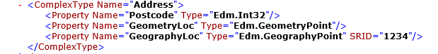
An ODataComplexValue for the Address type could be constructed as follows:
var addressValue = new ODataComplexValue
{
    Properties = new ODataProperty[]
    {
        new ODataProperty { Name = "Street", Value = new ODataPrimitiveValue("Zi Xing Rd") },
        new ODataProperty { Name = "City", Value = new ODataPrimitiveValue("Shanghai") },
        new ODataProperty { Name = "Postcode", Value = new ODataPrimitiveValue("200000") },
        new ODataProperty { Name = "GeometryLoc", Value = new ODataPrimitiveValue(GeometryPoint.Create(12.34, 56.78)) },
        new ODataProperty { Name = "GeographyLoc", Value = new ODataPrimitiveValue(GeographyPoint.Create(12.34, 56.78)) },
    }
};
Construct more complex spatial instances
Directly creating these instances using Spatial APIs would be a bit complicated. So we highly recommend that you download and add the SpatialFactory.cs file to your project and use the GeometryFactory or the GeographyFactory class to construct more complex spatial instances.
Here are some sample code of how to use the factory classes to create spatial instances:
// Create a GeographyMultiPoint.
GeographyMultiPoint multiPoint = GeographyFactory.MultiPoint().Point(-90.0, 0.0).Point(0.0, 90.0).Build();

// Create a GeometryMultiPolygon.
GeometryMultiPolygon multiPolygon = GeometryFactory.MultiPolygon()
    .Polygon().Ring(-5, -5).LineTo(0, -5).LineTo(0, -2)
    .Polygon().Ring(-10, -10).LineTo(-5, -10).LineTo(-5, -7).Build();

// Create a GeometryLineString.
GeometryLineString lineString = GeometryFactory.LineString(10, 20).LineTo(20, 30).Build();

// Create a GeometryCollection.
GeometryCollection collection = GeometryFactory.Collection()
    .MultiPoint().Point(5, 5).Point(10, 10)
    .LineString(0, 0).LineTo(0, 5)
    .Collection()
        .Point(5, 5);
More samples could be found in the test cases of the Microsoft.Spatial.Tests project. Please find the source code here.
References
Feedback
Coming soon: Throughout 2024 we will be phasing out GitHub Issues as the feedback mechanism for content and replacing it with a new feedback system. For more information see: https://aka.ms/ContentUserFeedback.
Submit and view feedback for