Display routes and directions on a map
Note
MapControl and map services requite a maps authentication key called a MapServiceToken. For more info about getting and setting a maps authentication key, see Request a maps authentication key.
Request routes and directions, and display them in your app.
Note
To learn more about using maps in your app, download the Universal Windows Platform (UWP) map sample.
If mapping isn't a core feature of your app, consider launching the Windows Maps app instead. You can use the bingmaps:, ms-drive-to:, and ms-walk-to: URI schemes to launch the Windows Maps app to specific maps and turn-by-turn directions. For more info, see Launch the Windows Maps app.
An intro to MapRouteFinder results
Here's how the classes for routes and directions are related:
The MapRouteFinder class has methods that get routes and directions. These methods return a MapRouteFinderResult.
The MapRouteFinderResult contains a MapRoute object. Access this object through the Route property of the MapRouteFinderResult.
The MapRoute contains a collection of MapRouteLeg objects. Access this collection through the Legs property of the MapRoute.
Each MapRouteLeg contains a collection of MapRouteManeuver objects. Access this collection through the Maneuvers property of the MapRouteLeg.
Get a driving or walking route and directions by calling the methods of the MapRouteFinder class. For example, GetDrivingRouteAsync or GetWalkingRouteAsync.
When you request a route, you can specify the following things:
You can provide a start point and end point only, or you can provide a series of waypoints to compute the route.
Stop waypoints adds additional route legs, each with their own Itinerary. To specify stop waypoints, use any of the GetDrivingRouteFromWaypointsAsync overloads.
Via waypoint defines intermediate locations between stop waypoints. They do not add route legs. They are merely waypoints that a route must pass through. To specify via waypoints, use any of the GetDrivingRouteFromEnhancedWaypointsAsync overloads.
You can specify optimizations (For example: minimize the distance).
You can specify restrictions (For example: avoid highways).
Display directions
The MapRouteFinderResult object contains a MapRoute object that you can access through its Route property.
The computed MapRoute has properties that provide the time to traverse the route, the length of the route, and the collection of MapRouteLeg objects that contain the legs of the route. Each MapRouteLeg object contains a collection of MapRouteManeuver objects. The MapRouteManeuver object contains directions that you can access through its InstructionText property.
Important
You must specify a maps authentication key before you can use map services. For more info, see Request a maps authentication key.
using System;
using Windows.UI.Xaml;
using Windows.UI.Xaml.Controls;
using Windows.Services.Maps;
using Windows.Devices.Geolocation;
...
private async void button_Click(object sender, RoutedEventArgs e)
{
   // Start at Microsoft in Redmond, Washington.
   BasicGeoposition startLocation = new BasicGeoposition() {Latitude=47.643,Longitude=-122.131};

   // End at the city of Seattle, Washington.
   BasicGeoposition endLocation = new BasicGeoposition() {Latitude = 47.604,Longitude= -122.329};

   // Get the route between the points.
   MapRouteFinderResult routeResult =
         await MapRouteFinder.GetDrivingRouteAsync(
         new Geopoint(startLocation),
         new Geopoint(endLocation),
         MapRouteOptimization.Time,
         MapRouteRestrictions.None);

   if (routeResult.Status == MapRouteFinderStatus.Success)
   {
      System.Text.StringBuilder routeInfo = new System.Text.StringBuilder();

      // Display summary info about the route.
      routeInfo.Append("Total estimated time (minutes) = ");
      routeInfo.Append(routeResult.Route.EstimatedDuration.TotalMinutes.ToString());
      routeInfo.Append("\nTotal length (kilometers) = ");
      routeInfo.Append((routeResult.Route.LengthInMeters / 1000).ToString());

      // Display the directions.
      routeInfo.Append("\n\nDIRECTIONS\n");

      foreach (MapRouteLeg leg in routeResult.Route.Legs)
      {
         foreach (MapRouteManeuver maneuver in leg.Maneuvers)
         {
            routeInfo.AppendLine(maneuver.InstructionText);
         }
      }

      // Load the text box.
      tbOutputText.Text = routeInfo.ToString();
   }
   else
   {
      tbOutputText.Text =
            "A problem occurred: " + routeResult.Status.ToString();
   }
}
This example displays the following results to the tbOutputText text box.
Total estimated time (minutes) = 18.4833333333333
Total length (kilometers) = 21.847

DIRECTIONS
Head north on 157th Ave NE.
Turn left onto 159th Ave NE.
Turn left onto NE 40th St.
Turn left onto WA-520 W.
Enter the freeway WA-520 from the right.
Keep left onto I-5 S/Portland.
Keep right and leave the freeway at exit 165A towards James St..
Turn right onto James St.
You have reached your destination.
Display routes
To display a MapRoute on a MapControl, construct a MapRouteView with the MapRoute. Then, add the MapRouteView to the Routes collection of the MapControl.
Important
You must specify a maps authentication key before you can use map services or the map control. For more info, see Request a maps authentication key.
using System;
using Windows.Devices.Geolocation;
using Windows.Services.Maps;
using Windows.UI;
using Windows.UI.Xaml.Controls;
using Windows.UI.Xaml.Controls.Maps;
...
private async void ShowRouteOnMap()
{
   // Start at Microsoft in Redmond, Washington.
   BasicGeoposition startLocation = new BasicGeoposition() { Latitude = 47.643, Longitude = -122.131 };

   // End at the city of Seattle, Washington.
   BasicGeoposition endLocation = new BasicGeoposition() { Latitude = 47.604, Longitude = -122.329 };


   // Get the route between the points.
   MapRouteFinderResult routeResult =
         await MapRouteFinder.GetDrivingRouteAsync(
         new Geopoint(startLocation),
         new Geopoint(endLocation),
         MapRouteOptimization.Time,
         MapRouteRestrictions.None);

   if (routeResult.Status == MapRouteFinderStatus.Success)
   {
      // Use the route to initialize a MapRouteView.
      MapRouteView viewOfRoute = new MapRouteView(routeResult.Route);
      viewOfRoute.RouteColor = Colors.Yellow;
      viewOfRoute.OutlineColor = Colors.Black;

      // Add the new MapRouteView to the Routes collection
      // of the MapControl.
      MapWithRoute.Routes.Add(viewOfRoute);

      // Fit the MapControl to the route.
      await MapWithRoute.TrySetViewBoundsAsync(
            routeResult.Route.BoundingBox,
            null,
            Windows.UI.Xaml.Controls.Maps.MapAnimationKind.None);
   }
}
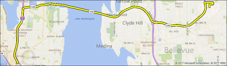
This example displays the following on a MapControl named MapWithRoute.
Here's a version of this example that uses a via waypoint in between two stop waypoints:
using System;
using Windows.Devices.Geolocation;
using Windows.Services.Maps;
using Windows.UI;
using Windows.UI.Xaml.Controls;
using Windows.UI.Xaml.Controls.Maps;
...
private async void ShowRouteOnMap()
{
  Geolocator locator = new Geolocator();
  locator.DesiredAccuracyInMeters = 1;
  locator.PositionChanged += Locator_PositionChanged;

  BasicGeoposition point1 = new BasicGeoposition() { Latitude = 47.649693, Longitude = -122.144908 };
  BasicGeoposition point2 = new BasicGeoposition() { Latitude = 47.6205, Longitude = -122.3493 };
  BasicGeoposition point3 = new BasicGeoposition() { Latitude = 48.649693, Longitude = -122.144908 };

  // Get Driving Route from point A  to point B thru point C
  var path = new List<EnhancedWaypoint>();

  path.Add(new EnhancedWaypoint(new Geopoint(point1), WaypointKind.Stop));
  path.Add(new EnhancedWaypoint(new Geopoint(point2), WaypointKind.Via));
  path.Add(new EnhancedWaypoint(new Geopoint(point3), WaypointKind.Stop));

  MapRouteFinderResult routeResult =  await MapRouteFinder.GetDrivingRouteFromEnhancedWaypointsAsync(path);

  if (routeResult.Status == MapRouteFinderStatus.Success)
  {
      MapRouteView viewOfRoute = new MapRouteView(routeResult.Route);
      viewOfRoute.RouteColor = Colors.Yellow;
      viewOfRoute.OutlineColor = Colors.Black;

      myMap.Routes.Add(viewOfRoute);

      await myMap.TrySetViewBoundsAsync(
            routeResult.Route.BoundingBox,
            null,
            Windows.UI.Xaml.Controls.Maps.MapAnimationKind.None);
  }
}
Related topics
- Bing Maps Developer Center
- UWP map sample
- Design guidelines for maps
- Build 2015 video: Leveraging Maps and Location Across Phone, Tablet, and PC in Your Windows Apps
- UWP traffic app sample
Feedback
Coming soon: Throughout 2024 we will be phasing out GitHub Issues as the feedback mechanism for content and replacing it with a new feedback system. For more information see: https://aka.ms/ContentUserFeedback.
Submit and view feedback for